Get Land Surveying in Frederick, MD
Land surveying services for Frederick, MD property owners identify property boundaries, assist with construction or development projects, and resolve land disputes by connecting with experienced local contractors.
Property owners in Frederick, MD often turn to land surveying services to support a variety of planning and development projects. Whether preparing for new construction, boundary adjustments, or property improvements, accurate land surveys provide essential information to ensure projects are grounded in precise property data. Exploring local options can help property owners compare the expertise and experience of nearby service providers, making it easier to find the right support for their specific needs.
Understanding the scope and benefits of land surveying can help property owners make informed decisions as they plan their next steps. Local contractors who specialize in land surveying are equipped to handle a range of property-related tasks, offering clarity and confidence in the planning process. Continuing to explore available options can lead to finding the right professionals to assist with your project’s success.
- Boundary Surveys - Necessary when establishing property lines for new construction or resolving land disputes in neighborhoods around Frederick, MD.
- Topographic Surveys - Used to create detailed maps of land elevation and features for planning landscaping or grading projects in areas like Ballenger Creek.
- Construction Staking - Essential for accurately marking building locations during new development or renovations in communities such as Urbana.
- ALTA/NSPS Land Title Surveys - Required for commercial property transactions or title insurance in busy commercial districts near downtown Frederick.
- Subdivision Surveys - Needed when dividing land parcels for sale or development within suburban neighborhoods around Frederick, MD.


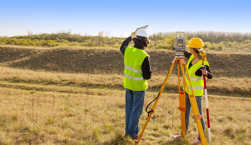
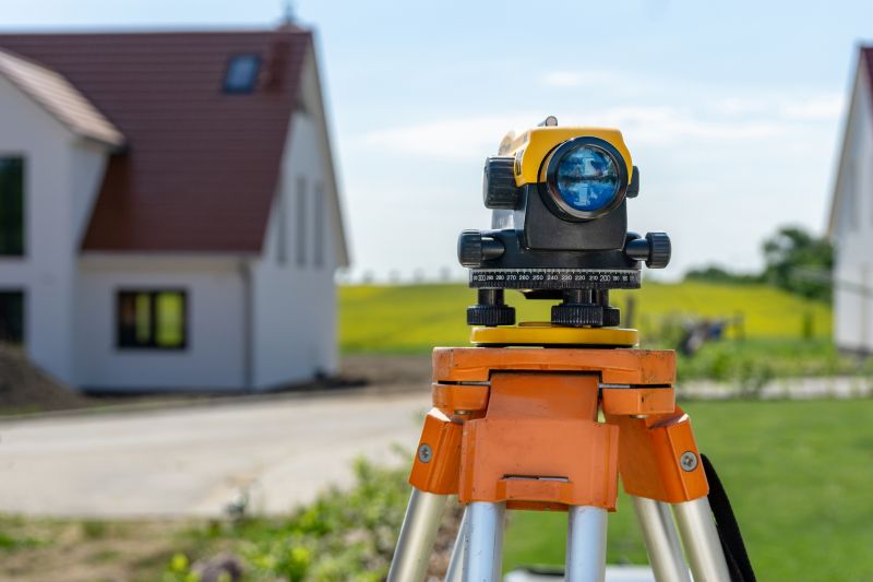
Land surveying services involve accurately measuring and mapping property boundaries, features, and topography. These surveys provide detailed information about a property's exact dimensions, boundary lines, and physical characteristics. Whether for new construction, property division, or legal documentation, professional surveyors use specialized tools and techniques to produce precise maps that serve as a reliable reference for property owners and developers. This process helps ensure that property lines are clearly defined and documented, reducing the risk of disputes or misunderstandings with neighbors or local authorities.
One of the primary problems land surveying helps solve is boundary disputes. When property lines are unclear or contested, a detailed survey can provide definitive evidence of where one property ends and another begins. This clarity is especially important when dividing land, planning new structures, or making improvements close to property lines. Additionally, land surveys assist in identifying existing features such as fences, driveways, or utility lines that may impact construction or property use. By providing a clear and official record of property details, survey services help homeowners avoid legal conflicts and ensure their plans are compliant with local regulations.
Land surveying services are commonly used for residential, commercial, and agricultural properties. Homeowners often seek surveys when purchasing a new home, planning additions, or installing fences and landscaping. Property developers and builders rely on surveys to establish accurate boundaries before starting construction projects. Farmers and landowners may also use surveying to subdivide large parcels of land or to prepare for sale or development. Regardless of property type, these services are essential for any situation where precise measurements and boundary clarity are needed to support property management and development plans.
Understanding when to hire a land surveyor can save time and prevent costly issues later on. If planning to build an extension, install a pool, or make significant landscaping changes, a professional survey can confirm property lines and identify potential obstacles. For property transactions, surveys provide official documentation that can help prevent boundary disputes. Even for routine property maintenance or fencing projects, knowing the exact property limits ensures that improvements are correctly placed. Connecting with experienced local contractors can provide the expertise needed to address these needs and ensure that property boundaries are accurately established and documented.
The overview below groups typical Land Surveying projects into broad ranges so you can see how smaller, mid-sized, and larger jobs often compare in Frederick, MD.
In many markets, a large share of routine jobs stays in the lower and middle ranges, while only a smaller percentage of projects moves into the highest bands when the work is more complex or site conditions are harder than average.
Smaller Land Surveys - Typical costs range from $250 to $600 for routine boundary or property line surveys in Frederick, MD. Many smaller projects fall within this range, especially for straightforward jobs on residential lots. Larger, more complex surveys can exceed this range but are less common.
Mid-Size Projects - Land surveying services for larger residential developments or small commercial sites usually cost between $1,000 and $3,000. These projects often involve detailed boundary mapping and topographic data collection, which local contractors handle regularly within this budget.
Large or Complex Surveys - Extensive projects such as large commercial developments or detailed topographic surveys can range from $3,500 to over $10,000. Such jobs are less frequent and typically involve significant planning and detailed analysis by experienced surveyors in the Frederick area.
Full Land Replacements or Subdivisions - Full property re-surveys or subdivision plans can reach $5,000 or more, depending on size and complexity. These high-end projects are less common and often require multiple survey phases by specialized local service providers.
Actual totals will depend on details like access to the work area, the scope of the project, and the materials selected, so use these as general starting points rather than exact figures.
Construction Site Planning - Land surveyors provide precise measurements and site layouts that help contractors plan foundations, grading, and infrastructure for new construction projects.
Boundary Line Establishment - Surveying professionals determine property boundaries, which is essential for resolving disputes and preparing for land development or fencing.
Topographic Mapping - Creating detailed topographic maps involves measuring land elevations and features, skills closely related to land surveying techniques.
Subdivision Design - Surveyors assist in dividing large parcels into smaller lots, ensuring compliance with local zoning and planning requirements.
Utility and Infrastructure Planning - Accurate land measurements support the installation and planning of utilities, roads, and drainage systems.
Environmental and Land Use Assessments - Surveying skills are used to evaluate land features and boundaries for environmental impact studies and land use planning.

When evaluating land surveying service providers in Frederick, MD, it’s important to consider their experience with projects similar to what’s needed for the property. A seasoned professional will have a clear understanding of local regulations, terrain, and common challenges encountered in the area. Asking about their background with comparable projects can help ensure they have the relevant expertise to deliver accurate and reliable results. This focus on experience can lead to a smoother process and more dependable outcomes for the homeowner’s specific land surveying needs.
Clear, written expectations are vital when choosing a land surveying service provider. A reputable contractor should be able to provide a detailed scope of work, outlining what services will be performed, deliverables, and any necessary preparations. Having this information in writing helps prevent misunderstandings and ensures that both parties are aligned on the project’s scope. Homeowners should seek service providers who communicate their plans transparently and are willing to clarify any questions before work begins, fostering a better overall experience.
Reputation and communication are key factors in selecting a reliable land surveying professional. Reputable local contractors often have references or examples of past projects that can be reviewed to gauge their quality of work. Good communication throughout the process-such as prompt responses to inquiries and clear updates-can make a significant difference in the overall experience. While this site introduces homeowners to local options, it’s essential to connect with service providers who are known for professionalism, transparency, and responsive communication to ensure the land surveying work is handled efficiently and accurately.
Property owners in Frederick, MD use Land Surveying services for practical projects around their homes and businesses. This guide focuses on everyday jobs and straightforward project options.

Land surveying services are often needed when property owners in Frederick, MD, are planning to build additions, fences, or new structures on their land. Accurate boundary lines are essential to avoid disputes with neighbors and ensure that construction projects stay within legal property limits. Additionally, property owners might seek surveying work when purchasing land or resolving property line disagreements, helping to clarify exact boundaries and prevent future conflicts.
In other situations, property owners may require land surveying to establish precise measurements for subdivision or development purposes. This can be especially relevant in Frederick’s growing neighborhoods, where clear property boundaries are crucial for zoning compliance and future planning. Local contractors specializing in surveying can provide the detailed information needed to support property improvements, land development, or legal documentation.
What is land surveying? Land surveying involves measuring and mapping land boundaries, features, and topography to establish precise property lines and assist with construction or development projects.
Why is land surveying important before construction? Land surveying provides accurate boundary and site data, helping to prevent disputes and ensure construction is built within legal property lines.
What types of land surveying services are available? Services include boundary surveys, topographic surveys, construction staking, and subdivision planning, depending on the project needs.
How do local contractors perform land surveys? They use specialized equipment and techniques to gather detailed measurements and create maps that accurately represent the land features.
How can I find qualified land surveyors in Frederick, MD? Contacting local service providers through a lead generation platform can connect you with experienced land surveyors in the area.
Property Boundary Clarification - Use land surveying services to clearly define property lines before installing fences or landscaping projects.
Land Division and Parceling - When planning to subdivide land or add new parcels, local contractors can provide precise surveys to ensure proper boundaries.
Construction Planning and Permitting - Accurate land surveys help property owners plan additions or renovations and navigate local permitting requirements smoothly.
Topographical Mapping for Landscaping - Land surveying can create detailed topographical maps to assist with grading, drainage, and landscaping projects.
If you are thinking about Land Surveying for a property in Frederick, MD, this guide is meant to help you understand the work, the typical project types, and how different options might fit your plans.
When you are ready, you can use the quote form on this page to share a few details about your project. From there, local pros can review the basics and respond with options that match what you have in mind.